Pathfinder Pro, 2025
Pathfinder Pro, 2025
Making hiking experience safer and more seamless
Making hiking experience safer and more seamless
Making hiking experience safer and more seamless
Mobile App
UX / UI
Academic Project
8 min read
Pathfinder Pro is an academic concept app for wearables inspired by a real hiking experience. When a group of friends struggled to juggle multiple apps for maps, weather, and safety, the idea for an all-in-one hiking companion was born. This redesigned version was fully created by me, with many thanks to my old teammates for the initial concept ;)
Pathfinder Pro is an academic concept app inspired by a real hiking experience. When a group of friends struggled to juggle multiple apps for maps, weather, and safety, the idea for an all-in-one hiking companion was born. This redesigned version was fully created by me ;)
Timeline
Timeline
Jun - Aug (3 months)
Jun - Aug (3 months)
Team
Team
Just me!
Just me!
Role
Role
UX Designer
UX Designer
Skills
Skills
Figma, Prototyping
Figma, Prototyping
Timeline
Jun - Aug (3 months)
Role
UX Designer
Team
Just me!
Skills
Figma, Prototyping
The problem
The problem
Exploring remote outdoor areas often comes with the challenge of unreliable phone signals and limited access to digital maps. Hikers, campers, and adventurers navigating forests, mountains, or rugged wilderness frequently struggle to stay oriented and connected. These issues become especially critical during emergencies, when locating oneself or contacting help can mean the difference between safety and danger. Outdoor explorers need a dependable way to navigate, communicate, and stay safe - even when completely off the grid.

How can I help hikers have a seamless experience while they are on a trail?
How can I help hikers have a seamless experience while they are on a trail?
How can I help hikers have a seamless experience while they are on a trail?
The solution :>
The solution :>
GPS tracking with real-time data
GPS tracking with real-time data
help hikers monitor their pace, distance, and progress.
Online & Offline maps
Online & Offline maps
for seamless navigation, even when signals fail.
for seamless navigation, even when signals fail.
Community
Community
where friends can share reviews, join events, and send messages.
where friends can share reviews, join events, and send messages.
How did I come up with these solutions? … Imagination, I guess :D

Research
Research
Understanding the problem
Understanding the problem
Understanding the problem
To identify problems, our group conducted interviews with hikers and outdoor enthusiasts to understand their challenges, needs, and expectations.
To identify problems, our group conducted interviews with hikers and outdoor enthusiasts to understand their challenges, needs, and expectations.
What challenges do you face when hiking or camping in remote areas?
What challenges do you face when hiking or camping in remote areas?
It depends on the level of the trail and duration of the hike. First aid, getting lost, insect bites, carrying supplies that are heavy over a long distance, crossing water, elevation.
It depends on the level of the trail and duration of the hike. First aid, getting lost, insect bites, carrying supplies that are heavy over a long distance, crossing water, elevation.
What features would make you feel safer during outdoor adventures?
What features would make you feel safer during outdoor adventures?
Always available ability to call a friend or emergency services
Highly precise geo-location
Loud alarm signal (to signal location to rescuers, or try to scare off wildlife)
Soft, warm to the touch, comforting
Highly localized weather and accurate forecasting
Language translation if hiking in another country
What do you think is missing from existing navigation or safety apps?
What do you think is missing from existing navigation or safety apps?
Trail guides
Chat directly to locals
Report something to authorities
Diving into risk factors:
Diving into risk factors:
Diving into risk factors:
68%
68%
68%
of hiking accidents are caused by falls, and 45% of those are fatal. (Yardi S., 2025)
of hiking accidents are caused by falls, and 45% of those are fatal. (Yardi S., 2025)
51.9%
51.9%
51.9%
of ankle sprains occur on unstable scree. (Lam, Lui, & Chan, 2011)
of ankle sprains occur on unstable scree. (Lam, Lui, & Chan, 2011)
From this, we concluded that…
From this, we concluded that…
Hikers and campers in remote areas have a strong need for reliable communication, precise geo-location, health tracking, and tools that make them feel safe.
Hikers and campers in remote areas have a strong need for reliable communication, precise geo-location, health tracking, and tools that make them feel safe.
Design
Design
My ultimate mission
My ultimate mission
For this project, I set out to create an app that acts as a one-stop shop for everything hikers need to make their experience safer and more seamless. The biggest challenge was combining many different functions into a single app without creating a complicated flow. By organizing these features into five clear categories shown in the navigation bar, Pathfinder Pro ultimately became a powerful and reliable companion for hikers in particular and adventurers in general.
For this project, I set out to create an app that acts as a one-stop shop for everything hikers need to make their experience safer and more seamless. The biggest challenge was combining many different functions into a single app without creating a complicated flow. By organizing these features into five clear categories shown in the navigation bar, Pathfinder Pro ultimately became a powerful and reliable companion for hikers in particular and adventurers in general.
Sitemap
Sitemap
Therefore, our sitemap organizes the app into five main pages: Home, Navigation, Activity, Community, and User Profile. Each section focuses on a core part of the experience: discovering trails, accessing live navigation tools, tracking personal progress, connecting with other hikers, and managing devices and settings. This structure keeps the app intuitive, clear, and easy to explore at any stage of the journey.
Therefore, our sitemap organizes the app into five main pages: Home, Navigation, Activity, Community, and User Profile. Each section focuses on a core part of the experience: discovering trails, accessing live navigation tools, tracking personal progress, connecting with other hikers, and managing devices and settings. This structure keeps the app intuitive, clear, and easy to explore at any stage of the journey.

Let's start, but safety first!
Let's start, but safety first!
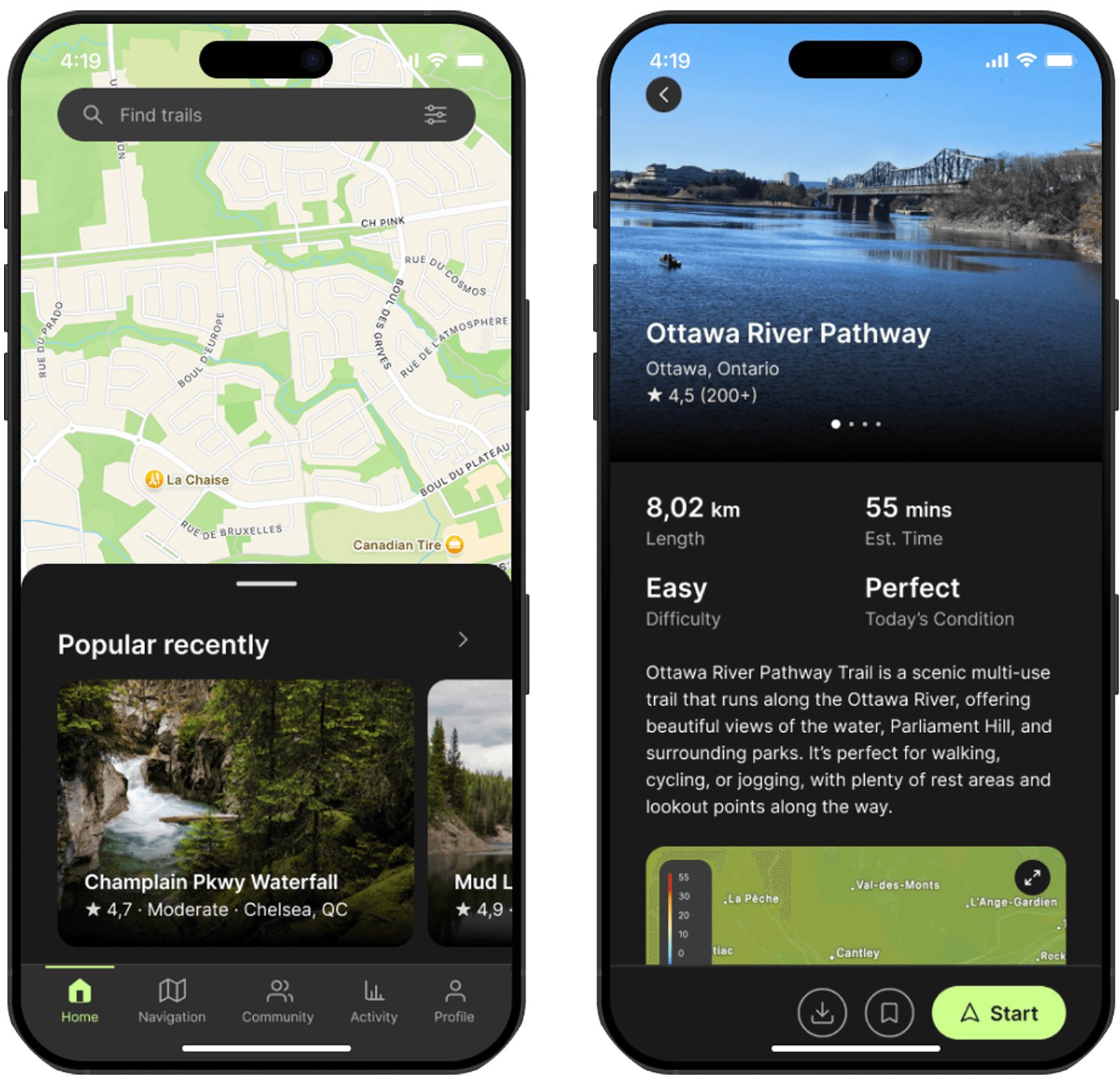
Hikers can start browsing popular trails recently, or pick one trail nearby that they are interested.
For each trail, Pathfinder Pro provides detailed trail data, today’s weather, and past reviews, giving hikers a clear overview to decide whether it’s safe to begin.
Hikers can start browsing popular trails recently, or pick one trail nearby that they are interested.
For each trail, Pathfinder Pro provides detailed trail data, today’s weather, and past reviews, giving hikers a clear overview to decide whether it’s safe to begin.
During the trail
During the trail
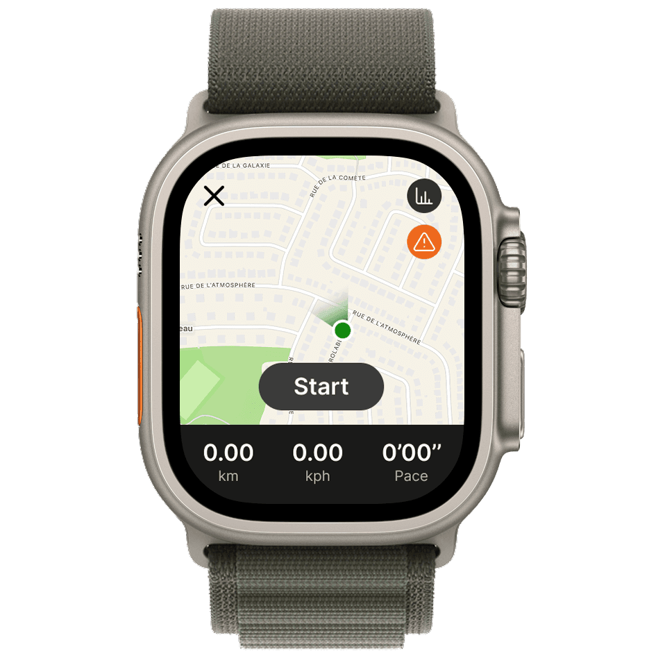
Pathfinder Pro offers both online and offline trail maps for hikers. They can easily download any trail and add it to their offline maps list.
When they begin a hike, the real-time tracking map appears with statistics displayed below. Moreover, the ‘Alert’ button is always visible, allowing adventurers to send messages to rescue teams or report dangerous situations to authorities.
What are my friends doing?
What are my friends doing?
The Community page functions like a mini social platform for hikers. Its main purpose is to connect people who share the same passion for exploring the outdoors. Here, users can view others’ reviews, see trending trails, check what their friends are hiking, and join upcoming events.
Pathfinder Pro also supports direct messaging and allows hikers to send messages or safety alerts to friends before or while on the trail, ensuring they stay connected everywhere, any time.
Events
Events
In the Events tab, users can browse a list of nearby activities. Each event includes essential details such as location, number of participants, and a description.
Users can also view organizer information to ensure they are reliable and trustworthy for a safe experience.
In the Events tab, users can browse a list of nearby activities. Each event includes essential details such as location, number of participants, and a description.
Users can also view organizer information to ensure they are reliable and trustworthy for a safe experience.
Activities summary
Activities summary
The Activity page allows hikers to reflect on their performance and track key health statistics such as heart rate, calories burned, and more. After completing a trail, all data is automatically saved, and users can review their summaries anytime.
At the bottom, I also added an achievement system to keep hikers motivated and aligned with their health goals.
Settings
Settings
The Settings page includes all essential functions for user preferences. One of the most important features is ensuring the app is properly connected to the user’s watch, allowing all data to sync and transfer seamlessly.
The Settings page includes all essential functions for user preferences. One of the most important features is ensuring the app is properly connected to the user’s watch, allowing all data to sync and transfer seamlessly.
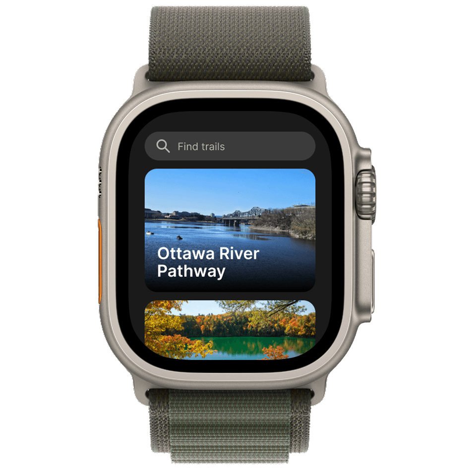
Wearables concept
Wearables concept
Designing for wearables brought its own challenges. With the small screen size and the watch’s primary focus on navigation and emergency alerts, I chose to simplify the interface and minimize secondary functions.
Designing for wearables brought its own challenges. With the small screen size and the watch’s primary focus on navigation and emergency alerts, I chose to simplify the interface and minimize secondary functions.
What's next?
What's next?
Due to time constraints, I wasn’t able to refine every function in this concept app. However, these are the improvements I plan to make in the future:
Add "Trail preview" icon to every trail.
Adjust the wayfinding color to indicate when hikers are entering high-risk terrain.
Create a check-list of necessary tools for the trail.
Revamp the Settings page to display user reviews first, with all settings placed under a smaller secondary button.
Add micro-animations to improve component interactions and overall user experience.